
Petroleum prospectivity reports
Chronosurveys produces regional prospectivity reports of areas where its consultants have worked in the past. These are supported by a dynamic GIS application.

Block 36 prospectivity report
Block 36 is located onshore, in the southwestern part of the Sultanate of Oman, bordering Saudi Arabia to the North and Yemen to the West. It covers 18625 km2 at the southeastern edge of the Eastern Rub al Khali Basin, a World-class oil and gas basin.
The block received limited exploration activity with only 8 wells drilled and ca. 1000 km of 2D lines.
Chronosurveys has produced a 63-pages long prospectivity report supported by a GIS project. This study is aimed for New Ventures and early stages of exploration of any company interested in knowing more about Block 36, onshore Oman, in the context of the current licensing round. It allows integration with proprietary data and other sources of data. The report and GIS project are marketed as a one-off purchase.
The authors have been working with this basin for several years and are available for advisory work, attend data room for asset evaluation and general geological consulting work.
The report includes:
- Brief historical overview
- Review of the stratigraphy of Oman, in particular the Rub al Khali Basin
- Petroleum systems elements description - source rock, reservoir, traps and plays
- Seismic sections and schematic cross sections from blocks 36, 49 and 38 and neighboring blocks in Yemen
- GIS project with key upstream data (wells, seismic lines, GDE maps) of block 36 and neighboring area
3.000,00 €
Final price, free shipping to selected countries
Free shipping to the following countries: Portugal
- Available
- Ships within 1-3 days1
The Mauritania-Senegal-Gambia-Guinea Bissau-Guinea Conakry Basin has been one of the most active areas for the E&P business in latest years. From practically unknown frontier area to an active oil and gas province. Discoveries like SNE, Tortue gas complex have put this basin on the radar of many companies, including several majors.
Chronosurveys has produced a regional prospectivity report supported by a GIS project. SEE MORE HERE.
The MSGBC Basin and current oil & gas licences. Brown lines are the 2D seismic sections georeferrenced in this report and the purple the schematic x-sections. This is a simplified version of the GIS project included with this report
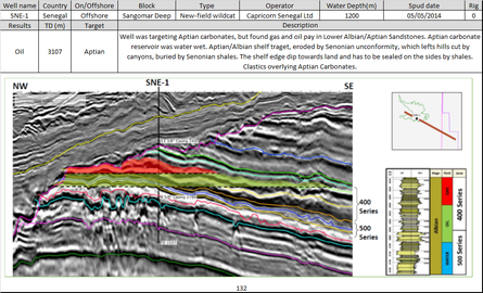
Example of well summary sheet with drilling data - spud date, geographical area, depths reached, objectives and results, together with a stratigraphic column, seismic section or cross-section. All wells ever drilled in the basin are included.

MSGBC Basin prospectivity report
Comprehensive report profusely illustrated with charts, seismic sections, maps, etc. Petroleum system’s elements and processes are described and discussed for the several areas of the basin. Summary sheets of 270 wells.
•380+ references (articles, thesis, presentations, brochures, etc) used
•Political, historical and economic background of each country
•96 georeferenced 2D seismic lines
•18 geological cross-sections
•900+ source rock parameter data points
•250+ reservoir parameter data points
•Gross depositional environment maps of 7 key intervals of the basin
•6 main plays identified, described and illustrated
•GIS project with Upstream, Geology, Geography and cultural data
•WebGIS project with key data for easy remote access.
15.000,00 €
Final price, free shipping to selected countries
Free shipping to the following countries: Portugal
- Available
- Ships within 1-3 days1

MSGBC Basin Prospectivity report: Senegal, The Gambia and AGC area
81-page long comprehensive report profusely illustrated with charts, seismic sections, maps, etc. Petroleum system’s elements and processes are described and discussed for the several areas of the basin. Summary sheets for 165 wells accessible from the GIS project.
•380+ references (articles, thesis, presentations, brochures, etc) used
•Political, historical and economic background of each country
•55 georeferenced 2D seismic lines
•13 geological cross-sections
•900+ source rock parameter data points
•250+ reservoir parameter data points
•Gross depositional environment maps of 7 key intervals of the basin
•6 main plays identified, described and illustrated
•GIS project with Upstream, Geology, Geography and cultural data
•WebGIS project with key data for easy remote access.
6.000,00 €
Final price, free shipping to selected countries
Free shipping to the following countries: Portugal
- Available
- Ships within 1-3 days1


